Depending on the organisation and Data Editing configurations, this toolbar is used to edit Spatial data and its attributes. 


Point

Users will only be able to add a point feature if the Layer being edited (from the Layers control under the Data Entry toolbar) is a Point layer.

    • Click on the Point tool to activate it 
    • Click a location on the map to add a point feature
    • Input the attributes of the new feature in the form in the left-hand sidebar. Fields marked with an asterisks (*) must not be left blank
    • Click Save

The appearance of the point on the map will depend on the style of that feature. For example, if the feature is a Park Asset and is a BBQ, it will be styled like all the other BBQ's on the map.

Line

Users will only be able to add a line if the Layer being edited (from the Layers control under the Data Entry toolbar) is a Line layer.

    • Click on the Line tool to activate it
    • Click once on the map to begin drawing the line
    • Click as many times as required to create the line feature 
    • Hit Esc to cancel the line creation
    • Double click to complete the line feature
    • Input the attributes of the new feature in the form in the left-hand sidebar. Fields marked with an asterisks (*) must not be left blank
    • Click Save

The appearance of the line on the map will depend on the style of that feature. For example, if the feature is a Park Asset and is a Gate, it will be styled like all the other Gates on the map.

Tip: When editing, users can press the 'Delete' key to delete a selected node.

Polygon

Users will only be able to add a polygon if the Layer being edited (from the Layers control under the Data Entry toolbar) is a Polygon layer.

    • Click on the Polygon tool to activate it 
    • Click once on the map to begin drawing the polygon
    • Click as many times as is required to create the polygon feature
    • Hit Esc to cancel the polygon creation
    • Double click to complete the polygon feature
    • Input the attributes of the new feature in the form in the left-hand sidebar. Fields marked with an asterisks (*) must not be left blank
    • Click Save

The appearance of the polygon on the map will depend on the style of that feature. For example, if the feature is a Park Asset and is a Garden Bed, it will be styled like all the other Garden Beds on the map.

Tip: When editing, users can press the 'Delete' key to delete a selected node.


Copy Feature
Geometry

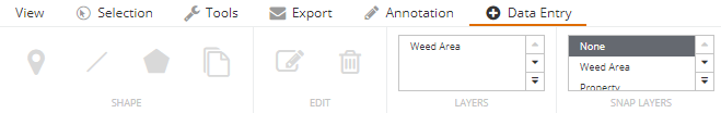
If a layer is selected from the Snap Layers control, not only can a data entry feature be created by snapping to those layers, but a feature can be created with geometry that is a direct replica of a specific feature from that layer. For this function to work, the snap layer and the data entry layer must both be the same geometry type (point, line or polygon).

For example if a user was monitoring weed areas and an entire property block was weeds, users can copy the geometry of that property without needing to trace around it during the creation process.

    • Click on a Snap Layer to enable snapping to that particular layer
    • Click the Copy Feature Geometry tool to activate it
    • Click a feature on the map that is from the previously configured snap layer
    • A feature will be created and highlighted that is a copy of the snap layer feature geometry. Users can edit the copied geometry if they wish: see Edit below
    • Input the attributes of the new feature in the form in the left-hand sidebar. Fields marked with an asterisks (*) must not be left blank
    • Click Save


Tip: Use the 'Auto Fill' button to automatically populate the data entry form with the attributes that are saved against the selected snap feature.


Edit

Edit an existing feature.

    • Click on the Edit tool to activate it 
    • Click on a feature to edit


Edit attributes

    • The attribute form in the left-hand sidebar will display. Change these attributes if required and click Save


Move the feature

    • To move the feature, hover the cursor over the centre icon of the feature and the cursor symbol change
    • Click and drag the feature to the new location


Edit the geometry (lines & polygons)

    • Select the feature
    • Click the Edit tool
    • Drag the vertices (grey and black dots) to the desired position or rotate the feature using the rounded arrow icon at the bottom right of the feature
    • Click Save


Delete

Delete an existing feature.

    • Select a feature on the Map
    • Click the Delete tool
    • Select Yes, delete (Remember, this cannot be undone)
    • The item will be deleted