Navigation Tool

Zoom in or out of the map with a single click.

Slider

A system administrator may set this slider to show an aerial image.

Drag the slider to progressively reveal the aerial image. With the toggle set to the far right, the aerial image with have 100% opacity as opposed to 0% on the far left.

Selection Tools

By default, the Point selection tool is active. Users can change the selection tool using this drop-down menu.

The currently active tool will displayed at the top level of the menu.


Scale Bar

Displays the current scale of the map.

The scale bar updates according to the current zoom level on the map.


Overview Map

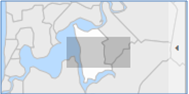
The Overview Map is dynamic, meaning the location identifier moves and resizes based on the current location and zoom scale within the map window. 


Users can click a location on the Overview Map and the corresponding view of the map window will change accordingly. 


Collapse the Overview Map by clicking the arrow on the right.